Discharge simulations in the Blue Nile Basin for future climate change assessments

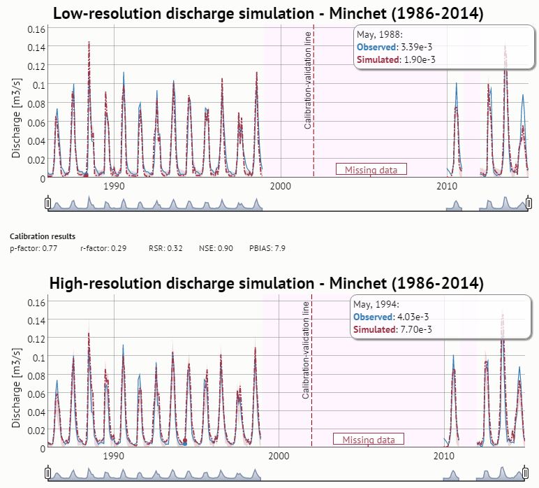
To be able to assess impact of climate change on watershed resources, for example the Blue Nile Basin, modelling of hydrology and sediment loss are crucial factors. Therefore calibrated models play an important role in the analysis of future risk and hazard assessment. This PhD in collaboration with the Water and Land Resource Centre in Addis Abeba, Ethiopia is trying to calibrate a hydrological model for the Blue Nile Basin and to apply a changing climate scenario for an assessment of risk and hazard. This blog post shows only an intermediate result of the final research.  

Migration patterns in Nepal: where do people go to for work

Labour migration in Nepal has existed for centuries, however for some years the rate has increased dramatically reaching about 1500 person per day leaving the country to find work abroad. How can migration flowpaths be visualized? Who and how many travel to what country for what reason? We try to visually describe migration flows from villages of origin in Nepal to people's respective destinations. At a glance migration clusters can be seen in this circlized migration graph.  

How poor are the poor in Laos? New approaches to measure poverty – Part 1

What exactly constitutes poverty? When is a person considered poor, and how many poor people are there worldwide? Are certain population segements at greater risk of being poor than others? The goal of halven the proportion of people living below USD 1.25 a day within the MDG-agenda has been reached in September 2013. But has the living situation of the world's poorest people really improved? In fact, our multidimensional poverty measure for Laos shows that social inequalities have increased, and that assessing poverty requires differentiated means of measurement